All hail, Lusitania – Governance
At the age of 36, the autocratic Augustus Caesar became Emperor and protector of some 50 million souls who inhabited a territory stretching from the Mediterranean basin to the hinterlands bordering the Ocean. Iberia was of particular interest.
Between 28 and 24 BC, military campaigns had ended the long-standing wars against the people of Cantabria and Asturia whose mountainous terrain occupied much of the northern coast. The peace so secured was to last in Iberia for two centuries during which the transformation to a mirror-image of Roman civilisation would be achieved.
With typical adroitness, the administrators of the new Roman Empire created the provinces of Lusitania and Baetica in the south-west of Hispania. The former occupied the territory of what is present-day Portugal, from the river Douro southwards plus an area (now Spanish) stretching 350km to the east of the Ocean and bounded in the south by the river Guadiana.
This new “state” accommodated the Lusitanians plus the tribes of Conii, Celtici and Turduli who had already accepted the occupation and integrated with Roman ways including the formation of militia.

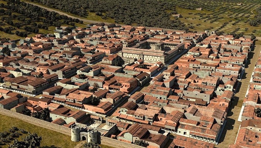
Augustus wisely chose Emerita Augusta (Mérida) to be the capital of Lusitania, this being a cosmopolitan city founded by veterans of the Legions V Alaudae and X Gemina. It was built on the Roman grid system and included all of the trappings of their civilisation with a forum, temples, theatres and public baths being built in an innovative architectural style previously unknown in Iberia, using vaulted ceilings and archways, squared blocks of stone, tiles of baked clay, cement, mortar and even concrete.
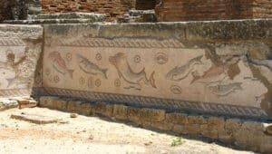
To this were added embellishments such as mosaics, stucco and statues which required the skill of the craftsmen who had immigrated to Scallabis (Santarém) at the behest of Julius Caesar and the engineers of the legions.
The remarkable administrative ability of the Romans was demonstrated by the creation of provincial cities designated as Conventus, each of which had a court of justice and a joint roman/autochthone elected assembly that counselled the appointed Governor.
Felicitas Julia Olissipo (Lisbon) was a separate legal municipality as were the townships of Ebora (Évora) and Salacia (Alcácer do Sal), while Scallabis Julia (Santarém) and Pax Julia (Beja) were the capitals of conventus Scalabitanus and conventus Pacensis.
Below the status of these cities were ruled five colonies of Roman citizens – mainly veterans – and 40 populis or stipendiarii being the equivalent of district councils. In all of these, the new architecture was employed during the first and second centuries AD but at varying rates of progress depending on the municipal importance.
To link the new administrative system, new roads with paved surfaces and bridges of stone or pontoons were constructed, which vastly improved the speed of communication both commercially and militarily.

Whether or not the wooden towers built at strategic points included the roman early semaphore system has not been revealed by excavation, but many examples of milestones have been found to mark routes which have disappeared with time.
One roman mile was equivalent to 1.48 km. The programme of road building stretched over two centuries and included many schemes for their widening or the building of bypasses where towns had outgrown their boundaries.
Due to an increase in traffic, stopping places were built at regular intervals equivalent to a day’s travel by horse, chariots or ox-drawn carts. For officials of the administration and for senior officers, a mansio (hotel) in the style of a large villa would provide superior accommodation while lesser mortals would have to be content with a taberna (hostel) with dormitories and a bar/shop where drinks and food such as cheeses, meats and preserves could be bought.
Services for such travellers were provided by mutationes staffed by wheelwrights, carpenters and blacksmiths with stabling and hirings for local journeys.
Inevitably, such facilities attracted camp followers who lived in shacks with an adjacent caupone (bordello) for their entertainment. At crossroads, these waystations evolved from being villages to small townships.

Despite the publication of numerous studies, the full extent of the roman road network has never been mapped and there are whole sections which remain to be discovered while others have been buried under modern urban constructions. But there are many routes which can still be traversed either on foot or, better still, with donkey and cart!
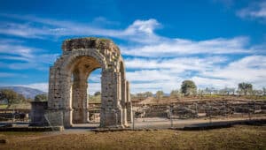
The ruins of the ancient city of Ammaia, situated in the Alentejo Parque Natural da Serra de São Mamede, provide a good example of a city initiated at the time of Augustus Caesar and then accoladed by Emperor Claudio who awarded the title of “civitas”.
Following later growth as a regional mining town with production of gold, quartz and other minerals, Ammaia received status as a “município” and continued to be of dominant local importance until the fifth century when it declined. While the ruins are not as spectacular as those of Conímbriga and Évora, it is well worth a visit to obtain an idea of a functional roman city of the Empire.